[Library Network] Kyoto University Rare Materials Digital Archive: Old Map of Yoshida Village in Yamashiro Province has been newly released
Old Map of Yoshida Village in Yamashiro Province held by the Kyoto University Museum has been newly released on Kyoto University Rare Materials Digital Archive.
The old map of Yoshida Village in Yamashiro Province (山城国吉田村古図) is a colored map showing the status of land ownership in Yoshida Village, Otagi-gun, Yamashiro Province, including the area that corresponds to the present-day Yoshida Campus of Kyoto University. This map measures about 176 cm x 265 cm, with annotations of the place, lot numbers, areas, owners, and tax payment recipients. Based on the content, it is estimated to have been drawn between the late 18th and mid-19th century.
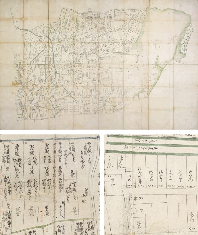
Above: whole map / Below left: fields / Below right: residental land
The original of the map can be seen in the special exhibition at the Kyoto University Museum from March 19 (Wed) to May 11 (Sun), 2025 (*Only duplicate will be displayed from March 19 to April 13, 2025).
As of March 19, 2025, Kyoto University Rare Materials Digital Archive provides 2,154,630 images of 25,595 titles.
- [Library Network] Kyoto University Rare Materials Digital Archive : Important Cultural Property "Dainihonshi Hensan Kiroku" Vol.62-66 (G.S. Letters) Newly Released (2026-04-17)
- [Library Network] Kyoto University Rare Materials Digital Archive : 2 items from the Kennaiki held by the Kyoto University Museum have been newly released (2026-03-13)
- [Library Network] Kyoto University Rare Materials Digital Archive : 309 items from the Kyō-ō Gokokuji Documents held by the Kyoto University Museum have been newly released (2026-03-10)
- [Library Network] Kyoto University Rare Materials Digital Archive: 310 items from the Kyō-ō Gokokuji Documents held by the Kyoto University Museum have been newly released (2025-03-27)
- [Library Network] Kyoto University Rare Materials Digital Archive: Old Map of Yoshida Village in Yamashiro Province has been newly released (2025-03-19)
- [Library Network] Kyoto University Rare Materials Digital Archive: 12 items from Dutch trade documents have been newly released (2025-03-04)
- [Library Network] Kyoto University Rare Materials Digital Archive: Suruga Date Documents (Early-modern) have been newly released (2025-02-13)
- [Library Network] Kyoto University Rare Materials Digital Archive: Important Cultural Property "Dainihonshi hensan kiroku" vol.56-61 (G.S. Letters) newly released (2024-11-08)
- [Library Network] Kyoto University Rare Materials Digital Archive: Madarajima Documents Have Been Newly Released By A Joint Project With Princeton University (2024-03-29)
- [Library Network] Kyoto University Rare Materials Digital Archive: 311 items from the Kyō-ō Gokokuji Documents held by the Kyoto University Museum have been newly released (2024-02-08)